Big Bend National Park
Author: Nicki Klein
My boyfriend and I had plans to spend a couple weeks in Texas and decided that in-between visiting friends in Austin and the San Antonio area, we’d spend 3 nights in Big Bend National Park since neither of us had ever been.
Big Bend National Park is located in a remote part of southern Texas, and in some parts, is separated from Mexico only by the Rio Grande. For more than 1,000 miles, the Rio Grande forms the border between Mexico and the United States, 118 of which lie in Big Bend. In fact, the name Big Bend comes from a large bend in the river that bounds the park. The park covers 801,163 acres and is the largest protected area of Chihuahuan Desert topography and ecology in the United States.
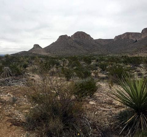
 We knew we wanted to do some backcountry camping, and after perusing the National Park site, we decided on the Outer Mountain Loop trail, a 30 mile, 3 day, 2 night, strenuous hike. We arrived at the Persimmon Gap Visitor Center, the first visitor center reached in the Park when coming in from the town of Marathon, on Saturday January 2nd, in the late afternoon. The ranger advised us that we could pay our camp entrance fee ($25) there, and register for our primitive campground for the night ($12). She also suggested a nearby hike, and told us that she’d prefer we visit the Panther Junction Visitor Center in the morning to get permits for the Outer Mountain Loop hike since they’re closer to the trail, and more knowledgeable about the skills and requirements preferred for this trail’s hikers. With our fees paid, and the knowledge that the Panther Junction Center opened at 9am the next morning, we left and headed south to the two northernmost trails in the Park. Dog Canyon and Devil’s Den are a pair of narrow ravines in the Santiago Mountains, a thin range that forms a boundary between BBNP and Black Gap Wildlife Management Area. Unlike the trails we see in Louisiana that are tree lined and marked with paint (aka blazes), the shrubbery of south Texas does little in helping mark a path, so cairns (piles of rocks) are used instead. With only a couple of hours of daylight left, Brian and I walked and climbed along the steep, rocky hillsides of the two ravines before making our way back to the car.


Our campsite for the night was at Nine Point Draw, just south of the trails we’d just hiked. The site is not marked with a sign (the ranger said they’d been having trouble with people messing with it—why, I’m not sure), but her directions were accurate, and we were able to easily find it. We had the place to ourselves, and quickly set up our tent, and began cooking in the bear box at our site in order to block the wind from delaying our dinner time. We both tend to be simple eaters, so for this meal, and both of our other dinners on this trip, we’d put a packet of instant rice in our cookware (an indistinguishable metal pot on an MSR Pocket Rocket), followed by a can of corn, a can of black beans, and a small can of salsa (either verde or red). We didn’t drain any of them because leaving the liquid creates a soup-like meal. Heat until hot, and that’s dinner. Each night we’d also use my Jetboil to (super quick-like) heat water for tea. Brian said the tea kept him warm in the 30 degree temps. I said he’s crazy. After dinner, we walked the mile or so from our site to the main road, than along the Terilingua Ranch Road. We kept our headlamps off as much as possible, although we had to use them a couple times to prevent twisting an ankle on the heavily rutted road. Brian prefers his Black Diamond lamp, and I prefer my Petzl Tikka RXP (although a word of warming-this lamp will absolutely lose its charge in cold weather-I sleep with mine loosely around my neck, under my jacket, to keep it warm). Wanting to be completely packed and ready at the visitor center at 9am to get our permits, we called it an early night and went to bed.
I woke up the next morning warm (I’d stuffed myself into my 0F sleeping bag and worn mySmartwool socks, Patagonia leggings, prAna pants, Smartwool baselayer shirt, prAna hooded shirt,Smartwool vest, the Northface Thermoball jacket, Northface gloves, and Backpacker beanie…I get cold easily*), but sore. The random piece of blue foam I’d slept on was absolutely not conducive to a good night’s sleep. Brian, on the other hand, was well rested having slept just fine on his Thermarest Trail Lite Sleeping Pad. *Side note: These are the same clothes I wore, in some variation, the entire trip. I fully attest to their durability and wicking capabilities. I never asked for Brian’s opinion, but he at least didn’t kick me out of the tent.
After we’d packed up and reached the Panther Junction Visitor Center, the ranger seemed apprehensive, to say the least, about our plans. She suggested that after caching water for the second half of our hike, and reaching the trail head, we’d be getting a late start on the 15 or so miles we’d need to complete that day. Instead, she suggested we do a day hike, camp at a primitive campground that night, then do a hike from the Chisos Basin the next day, backcountry camping on the South Rim, and hiking out our last planned day in the park. Rangers tend to err on the side of safety, but they generally have a good idea of what they’re talking about, so we went ahead and took her advice.
We decided to hike the Marufo Vega Loop, a trail that another ranger had told us was his favorite in the park. The NP site describes it as “a strenuous, but spectacular day hike or overnight backpacking trip.” With our daypacks packed with water and a few snacks and supplies, we headed out. Lucky for us, our trip in early January is a “perfect” time to go because the temperature never nears the 100F that can be reached at other times in the year. A sign at the beginning of the trail told us that the hike would be a 14-mile round-trip, close to the mileage we would have reached with our original plans.
The first section of the trail is flat, passing along mesquite, cacti and other brushy (and prickly) shrubbery.
But after less than a mile, the rocks appear. And the uphills. And the downhills. Switchbacks. Etc. And it never really gets easy again. But…the hike was spectacular. Although the clouds never let us see much blue in the sky, we didn’t get rained on, and the wispy clouds kept us guessing what we’d see next. We’d occasionally stop and try and see where the trail continued in the distance, but with all the switchbacks, cliffs, and canyons, what lay ahead was often a surprise.


After about 7 miles, we reached a sign that said an extra .5 mile would take us to the Rio. I enjoy the “details” (the small extras), as Brian likes to joke, so it was no surprise that I insisted on the additional trip. That half mile was straight down, obviously making the .5 mile back to the main trail straight up, but with all the elevation variation throughout the hike, this wasn’t necessarily any more strenuous than anything we’d already done.
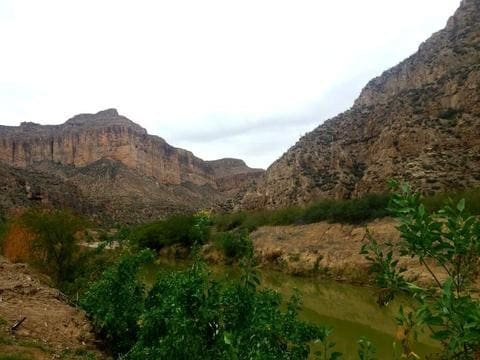
We finished the hike in approximately 6 hours, and then got in our car and made the short drive to the Boquillas Canyon Trailhead. This was a short (1.5 mile roundtrip) hike that had been recommended to us by numerous people. The hike was quick, and beautiful.

For our final activity of the day, we drove to the Hot Springs, also known as Boquillas Hot Springs. The spring is part of a former resort developed by J.O. Langford in 1909. There is a short hike one can take to this location, and there are primitive (aka not Honda Civic friendly) roads, but there is also a 2 mile unpaved road that most cars can take to reach the Springs. This is the one we took. Our vehicle was fine, but taking an RV or trailer on that road is not advisable due to the various twists and turns (signage explains this). After parking our car, we made the short walk to the spring, passing petroglyphs left by Apaches many years ago. The spring is frequently submerged by the Rio Grande, but when we got there, the water was low, and soaking in the 105 F water was perfect after almost 17 miles of hiking.

Photo Credit: NPS Photo
After the sun went down, we rushed to change, and drove off in search of our campsite at Government Spring, the closest campsite to the Chisos Basin Visitor Center, where we’d start our hike the next day. We followed what was already becoming a routine: setting up our tent, making dinner, and drinking tea and set an alarm for early in the morning.
We woke up to darkness and packed up our gear and made breakfast (oatmeal mixed with peanut butter, flax and chia seeds, Louisiana honey, and half a banana—the same thing we’d eat for breakfast everyday, and also what we both eat most mornings anyways). With our bags packed for the backcountry portion of our trip we headed 6 miles south to the Visitor Center, having never seen our campsite surroundings from the night before.
Because we’d already gotten our permits and reserved our campsite for the night, as soon as we parked the car at the Chisos Basin Visitor Center and Lodge, we grabbed our packs and hit the trail. We’d purchased a Chisos Mountain map at the Visitor Center the day before, and decided that we’d hike up the Pinnacles Trail, and down the Laguna Meadow Trail the next morning.

Although we had more weight this first day, and the Pinnacles Trail is much more steep, we both knew our quads could handle the hike up Pinnacles better than our knees could handle the hike down. The day was very cloudy, and cold. In areas where the sun hadn’t reached, frost and (some) snow were visible.
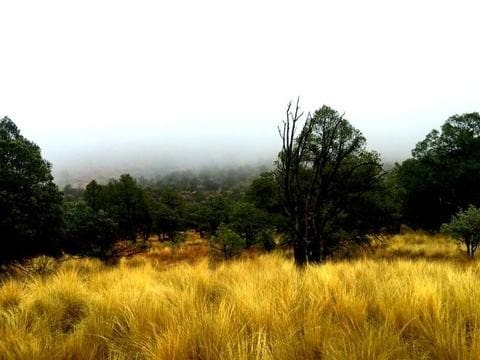


Within a couple hours, we we’d hiked the 6.3 miles (and a little extra because we got “lost” looking for our campsite) and were reaching Southeast Rim Campsite #1, “one of the nation’s best campsites, according to Backpacker Magazine,” and per the ranger at Panther Junction. The views were supposed to be amazing, but when we reached the rim, all we saw was a bright white backdrop—we were contained within cloud upon cloud.

We set up our camp, the first time doing so in daylight on this trip, grabbed our daypacks, and spent the afternoon and early evening hiking approximately 10 additional miles along the SE, NE, E and SW rims, the Juniper Canyon Trail, the Boot Canyon Trail, and the Colima Trail. As the day progressed, so did the sun’s warmth, which I greatly appreciated, and occasionally the clouds would part, providing spectacular views of mountaintops (though we never saw what was below us).


Although it was only 5p, we were both starving, and the temperature was dropping. Dinner and tea were quick, and we were in our tent shortly after 6. We’d set an alarm for shortly before 6am, and although 12 hours in a tent is a LOT of time, the shelter from the misty clouds and chill provided by our all season tent was MUCH appreciated.
After a less than perfect nights rest (stupid blue foam pad), I turned on my headlamp and poked my head outside the tent. All I could see was condensation and mist…again, we were in the clouds.

We knew there was no point in trying to dry out any of our gear in this weather, so everything was packed up (we aired everything out when we got to our destination that night), oatmeal was eaten, and we headed along the South Rim Trail in order to meet up at the Laguna Meadow Trail junction and make our way back to the Basin. Other than a brief stop at the composting toilet (do your business, than put a scoop of compost on top and close the lid), we powered through the 5.8 miles back to the car. The clouds were less prevelant this morning, and we were actually able to see some of the Basin, although we never did see that “spectacular” view from our campsite (a Google image search later provided it was quite beautiful).


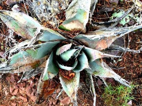
Even with the cold and overcast weather, I absolutely enjoyed my time in Big Bend. The variety of landscape really surprised me. What I expected to see was cacti, and instead I saw foliage, many different types of trees, grasses, rocks, canyons, meadows, etc. It seemed every turn took us to a different landscape. Big Bend truly was a jungle in the desert, and it definitely exceeded my expectations.
Tips and take home messages
With this trip, Brian and I learned what our hiking capabilities together truly were. As I mentioned earlier, rangers have to keep visitors safe, and they don’t know a hikers capabilities. Listen closely to a ranger’s suggestions, but also be confident in your own capabilities. You know your hiking style and experience better than anyone else. Looking back on our trip, we now know we could have done the Outer Mountain Loop trail as we’d planned. But, neither of us regrets the trails we did instead. We simply need to return to Big Bend to complete our original plan.
Be prepared for whatever park you go to. Know which roads your vehicle can handle. Research whether you need to cache water, get permits ahead of time or at the ranger station. Know what “the facilities” are like—in Big Bend, bring a trowel, and know you have to pack EVERYTHING out…that includes toilet paper. Sure, you’ll probably get away with hiding your waste under a rock, but don’t do it. Yuck. Make sure you have everything you need. Big Bend is remote: for last minute supplies, stop in the surrounding towns of Alpine or Marathon. There are some small gas stations in the park, but you’ll be paying much more for gas and amenities than you would at a locations outside the park. Finally, tell a responsible person what your plans are. Cell phone service is often unreliable in National Parks. All in all, PLAN! Oh, and definitely break in your gear before you go–wear your hiking boots for a walk around the neighborhood, practice setting up your tent, know how to turn on (and off) your headlamp. Trying to get used to a new piece of gear in the wilderness is not fun, and can be downright dangerous.
If you plan ahead and are prepared, a trip to a National Park is a wonderful experience. And even if those plans change, that’s all part of the adventure. Enjoy it!